
- PAD-US is America’s official national inventory of U.S. terrestrial and marine protected areas (List of National Geospatial Data Assets) that are dedicated to the preservation of biological diversity and to other natural, recreation and cultural uses, managed for these purposes through legal or other effective means. PAD-US also includes the best available aggregation of federal land and marine areas provided directly by managing agencies, coordinated through the FGDC Federal Lands Working Group.
Refineries in Each Of the PAD area
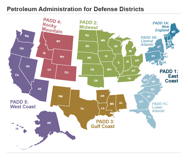
PADD: Petroleum Administration for Defense Districts
- PAD District 1 (East Coast) is composed of the following three subdistricts:
- Subdistrict 1A (New England): Connecticut, Maine, Massachusetts, New Hampshire, Rhode Island, Vermont.
- Subdistrict 1B (Central Atlantic): Delaware, District of Columbia, Maryland, New Jersey, New York, Pennsylvania.
- Subdistrict 1C (Lower Atlantic): Florida, Georgia, North Carolina, South Carolina, Virginia, West Virginia.
-
PAD District 2 (Midwest): Illinois, Indiana, Iowa, Kansas, Kentucky, Michigan, Minnesota, Missouri, Nebraska,
North Dakota, South Dakota, Ohio, Oklahoma, Tennessee, Wisconsin. - PAD District 3 (Gulf Coast): Alabama, Arkansas, Louisiana, Mississippi, New Mexico, Texas.
- PAD District 4 (Rocky Mountain):Colorado, Idaho, Montana, Utah, Wyoming.
- PAD District 5 (West Coast): Alaska, Arizona, California, Hawaii, Nevada, Oregon, Washington.
Lands in PAD-US are mainly open space/resource lands owned in fee by agencies and nonprofits. Conservation easements suitable for distribution in the public domain are also included. The current data set includes the “GAP Status Codes” of these lands, indicating how they are being managed for conservation purposes. A measure of public access for recreation is also included. PAD-US includes all Federal and most State and local lands.
How to Get PAD-US
Introduction
PAD-US data is available in a number of formats — special editions (for particular regions, etc.) can also be requested by contacting the PAD-US team.
Data Downloads
Downloads include .gdb (Esri Geodatabase) and shapefile formats for the entire dataset (U.S. and territories), state by state, and Department of the Interior Regions. The database is also available in KMZ format for state downloads. Download GIS data here.
Web Services
Web services allow USGS-served PAD-US data to be placed into interactive applications or desktop GIS sessions. Web services are provided for many variations of PAD-US, follow the link to explore all the options (note that layer files are also available for these same service themes, for use in desktop GIS projects).
PAD-US and Open Data
PAD-US data is in the public domain and is available for download in several formats, including Esri ArcGIS Geodatabase (.gdb), shapefile (.shp), and Keyhole Markup Language (.kmz) formats from the USGS PAD-US website. Various Web Mapping Services and PDF maps are also available.
Publishing PAD-US in many formats allow data to be viewed and analyzed in a variety of GIS platforms, both proprietary and open source. PAD-US data can be viewed and analyzed in Esri software products, QGIS, terriaJS, CartoDB, Tableau, various web viewer technologies, and many other software platforms. Data scales not immediately available for download may be obtained by contacting the PAD-US development team.
PAD-US data is also available to view without GIS software using online viewers on both the USGS PAD-US website and on ProtectedLands.net.
Printable Poster Maps
National and State poster maps of PAD-US data are available for download as .PDF and .jpg files. PDF map files are very large (often over 50–100mb) and support large format plotting of these PAD-US maps custom designed by GreenInfo Network.


Statistics
While any PAD-US data user can extract their own statistical measures from the database, there are two resources that can help users with this work:
- A detailed PAD-US spreadsheet (.xlsx) that summarizes protection status, public access and land management for the nation or by state, ecoregion, LCC, state or county (these statistics are for PAD-US 1.4 — PAD-US 2.0 statistics are forthcoming).
- To create some of those statistics, the PAD-US team created a “flat” vector shapefile of PAD-US that eliminates overlaps and prioritizes overlapping boundaries on ‘GAP Status Code’, ‘Public Access’, and feature ordering to summarize protected status and access. It can be used to replicate the statistics reporting, and also for other forms of analysis. This shapefile is available for download on the PAD-US statistics page as well.
- The mapping and reporting tool at www.ProtectedLands.net/map can also generate standard and custom statistics for particular areas in downloadable PDF reports.
Why are protected areas data important?
Detailed information about the conservation status of our country’s protected areas is crucial to improving our understanding of how well we are protecting the animals and plants that inhabit those areas. Natural resources decision-makers, planners, researchers, private interests and others also use this information in many other ways from locating and siting public resources such as recreation areas and energy facilities, to planning for and mitigating the impacts of climate change.
How GAP protected areas data can be used
Information about the conservation status of common species — a primary purpose of protected area analyses — is important for decision makers, planners, researchers, private interests, and others:
- Biodiversity: Protected areas (parks, preserves, etc.) have often been set aside without full understanding of their value to species conservation. As a result, many protected areas have little significance in terms of biodiversity, while many biodiversity-rich areas lack protection. Information provided by the PAD-US can help land conservation decision makers better match biodiversity goals to land protection programs and activities.
- Habitat Loss: Human population in the U.S. is predicted to grow by 25% in the next 50 years. This population increase, coupled with our land consumption patterns, means that there will be significant decreases in habitat for other species. Efforts to target the most effective lands for biodiversity conservation can offset some or many of the effects of habitat loss.
- Climate: Accelerating climate change is elevating the importance of effectively targeted species protection efforts. For many species, warming climates could push them to the brink of extinction unless habitat migration corridors can be set aside. Protected Areas analysis is critical to understanding where to focus such corridor planning.
- Energy Siting: Traditional and renewable energy projects such as oil, natural gas, solar and wind are planned and built across the U.S., often aided by governmental incentives. Protected area analysis can inform this planning and siting work, helping energy projects to find the best balance between habitat conservation and much-needed energy production.
- Management: Agencies and nonprofits that manage protected areas often lack good information about the full range of species that might be present or could be encouraged on their lands. The Gap Analysis Project can provide tools to improve land management practices that support continued biodiversity.
- Public Access: There is increasing interest and research on the benefits of publicly accessible open space. In the current version of PAD-US, access is fully attributed but primarily assigned categorically instead of through individual unit review. However, this data can be used to view lands open for public recreation, incorporated into web or mobile based recreation apps, and utilized in other analyses on public access. Now with a more complete inventory of city and county data in PAD-US, it may also be useful for local or regional recreation and open space planning.
Description of PAD-US data
How to cite data:
U.S. Geological Survey (USGS) Gap Analysis Project (GAP), 2018, Protected Areas Database of the United States (PAD-US): U.S. Geological Survey data release, https://doi.org/10.5066/P955KPLE.
Main purpose:
- The goals of the USGS Gap Analysis Project (GAP) are to provide landscape (e.g. State, watershed, regional and national) assessments of the conservation status of native vertebrate species and natural land cover types and to facilitate the application of this information to land management activities. The PAD-US geodatabase is required to organize and assess the status (i.e. land ownership and GAP Status Code) of protected areas for biodiversity protection. GAP has committed to develop and maintain PAD-US while implementing recommendations from the PAD-US Design Project (see A Map for the Future report) and expanding its scope to meet the needs of the recreation and public health communities (see Completing America’s Inventory of Public Parks and Protected Areas report), to the extent resources allow. The PAD-US geodatabase is built to support landscape analyses by describing all protected areas to illustrate patterns and possible relationships with other factors (e.g. urban areas, migration corridors) across the landscape. Characteristics of protected areas such as land owner, name, location, size, public access, and a measure of biodiversity management intent are compiled and standardized.
- Our current objective is to refine the PAD-US Data Manual to facilitate more efficient sharing of authoritative protected areas data between agencies and organizations that ultimately results in a comprehensive and accurate inventory of protected areas for the United States to meet a variety of needs (e.g. conservation, recreation, public health, transportation, energy siting, ecological, or watershed assessments and planning). In cooperation with UNEP-World Conservation Monitoring Centre (WCMC) and the Commission for Environmental Cooperation (CEC), GAP ensures PAD-US also supports continental and global decision making by maintaining World Database on Protected Areas (WDPA) Site Codes and International Union for the Conservation of Nature (IUCN) Categories for linkage to the North American Terrestrial Protected Areas Database and WDPA.
PAD-US data features:
PAD-US is available as a zipped national, DOI Region, or state geodatabase or shapefile. The following are included in PAD-US:
- Geographic boundaries of public land ownership (primarily Federal and State, with a significant amount of local government data, particularly for urban areas) and voluntarily provided private conservation lands (e.g., Nature Conservancy Preserves or land trust easements) from authoritative data sources.
- Standardized and original land owner, land manager, management designation and parcel name descriptions, areas and the source of geographic information of each mapped land unit.
- GAP Status Code — conservation measure of each parcel based on protection level categories that provide a measure of management intent for the long-term protection of biodiversity.
- IUCN category — a globally inter operable conservation measure required for a protected area’s inclusion into UNEP-World Conservation Monitoring Centre’s (WCMC) World Database on Protected Areas (WDPA).
- Reference information — aggregator source and original GIS source and dates.
- See “Supplemental_Info.txt” and metadata files included in download for more information.
How these data were aggregated:
- Boundaries, and their descriptors, available in spatial databases (i.e. shapefiles or geodatabase feature classes) from land management agencies are the desired and primary data sources in PAD-US. If these authoritative sources are unavailable, or the agency recommends another source, data may be incorporated by other aggregators such as non-governmental organizations. Data sources are tracked for each record in the PAD-US geodatabase (see below).
- ‘Aggregator Source’ describes the Aggregator (Organization) credited with data aggregation, version of PAD-US when the update occurred, feature class the data reside in (unless mixed), reference to the original source data file, and a reference to describe the State location to manage boundary inconsistencies between agency datasets (from State data-steward submissions only). ‘Aggregator Source’ is attributed in the format ‘organization name_PADUSversion+featureclass_filename.filetype’ (e.g. TNC_PADUS1_4_SecuredAreas2008.shp). State aggregations also include a reference to the State in the format ‘organization name_PADUSversion_filename.filetype_StateUSPS’. Aggregators may not always be able to define the geodatabase feature class as data may be mixed (e.g. MNDNR_PADUS2_0_MN2015_PADUS_MN_1.gdb_MN, NJOGIS_PADUS2_0Fee_OSPRI_August2017_NJ). Organization acronyms are used and underscore replaces spaces. A data aggregator submits data in the PAD-US format or includes nonprofit aggregators managing regional or national datasets with required fields for PAD-US translation. USGS is identified as aggregator when data translation is required (e.g. USGS_PADUS2_0Fee_BLM_SMA_ADMU_Union). Information about PAD-US Data Stewards and the Source Data they provide can be found at http://www.protectedlands.net/data-stewards/. This information will be made available on the USGS PAD-US web pages soon.
- The ‘GIS Source’ field in the PAD-US geodatabase identifies the source of spatial data the aggregator obtained (e.g. WYGF_whmas08.shp) for each record. Files names match original source data provided by managing agencies to increase update efficiency and data transparency. This field is in a state of transition to fully meet standards as the original ‘GIS Source’ is not always provided in aggregated datasets.
- The ‘GIS Source Date’ describes the date (yyyy/mm/dd) GIS data was obtained by the data source for aggregation. This date represents the best available data the GIS source has at the time.
Data limitations:
- The Digital Object Identifier https://doi.org/10.5066/P955KPLE for PAD-US 2.0 provides the persistent reference that should be used to obtain the data for use. The U.S. Geological Survey and all contributing data partners shall not be held liable for improper or incorrect use of the data described and (or) contained herein. All information is created with a specific end use or uses in mind. This is especially true for GIS data, which is expensive to produce and must be directed to meet the immediate program needs. These data were created with the expectation that they would be used for other applications; however, inappropriate uses are listed in metadata. The list is in no way exhaustive but should serve as a guide to assess whether a proposed use can or cannot be supported by these data. For many uses, it is unlikely that PAD-US will provide the only data needed, and for uses with a regulatory outcome, authoritative agency data and field surveys should verify the result. PAD-US is recommended for users seeking basic information about more than one agency or organization’s lands. Users should seek authoritative source data directly to answer questions regarding one agency or those requiring more frequent updates. Ultimately, it will be the responsibility of each data user to determine if these data can answer the question being asked.
PAD-US additional data
Previous versions of PAD-US data include PAD-US Version 1–1, 1–2, 1–3, 1.4, and 2.0. These are available in National, Regional, and State scales. Data are also available in shapefile and geodatabase formats.
Data Structure & Attributes
Introduction
For GIS users, understanding the technical structure of PAD-US is crucial to effective work. Here are some key elements to understand.
Geodatabase Structure
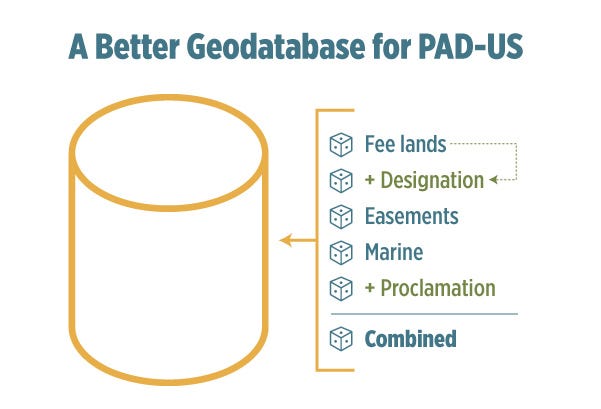
PAD-US is developed as an Esri Geodatabase with six feature classes of boundaries:
- ‘Fee’ (PADUS2_0Fee)- Lands owned outright by agencies and organizations
- ‘Easements’ (PADUS2_0Easement) — Lands with conservation or open space easements, held over private lands and public lands (easements sometimes exist over public fee lands) — this data comes directly into PAD-US from the National Conservation Easement Database (NCED)
- ‘Designations’ (PADUS2_0Designation) — A wide range of areas such as Wilderness Areas, National Monuments, Areas of Critical Environmental Concern, or Wild & Scenic Rivers. These do not represent ownership and often have been defined with different geometry than the ownership they overlay (especially Wilderness Areas). Several designations may overlay one another. ‘Designation’s are usually defined by Federal legislative actions which sometimes include specific maps of boundaries drawn through political processes — often with little or not reference to actual ownership boundaries. In addition, some State managed areas (Wildlife Management Areas, State Parks) may overlap fee owned Federal lands.
- ‘Marine’ (PADUS2_0Marine) — The National Oceanic and Atmospheric Administration (NOAA) contributes the boundaries of all Marine Protected Areas (MPA) from their MPA Inventory into PAD-US, which also contain State designations. Many Federal and State areas will be represented as Parks or Refuges in the ‘Fee’ feature class, as well as MPAs in the Marine feature class (MPA is another designation applied to the same unit). The Bureau of Ocean Energy Management (BOEM) also provides Federally managed Outer Continental Shelf lands that can be available for natural resource extraction. Many legitimate overlaps exist between MPAs as protection may vary at the surface or substrate, or for different species or seasons. Overlaps also exist between BOEM and NOAA provided data, with MPAs on top in the layering order.
- ‘Proclamations’ (PADUS2_0Proclamation) — Includes boundaries that provide context for protected areas, such as military lands (DOD). Most are suitable for illustration only as an outline, or exterior extent, as ownership within is not defined. NPS or USFS ‘Proclamation’ boundaries and FWS Approved Acquisition boundaries describe where each agency has authority to acquire lands, as voluntary opportunities arise. These boundaries may be somewhat or even vastly larger than actual agency fee ownership or easement interest. In addition, FWS Approved Acquisition boundaries may include significant limits for acquisition (for example, only 2,000 acres may be acquired within one of the largest mid western boundaries). ‘Proclamation’ and approved acquisition boundaries do NOT portray Federal ownership and often encompass private lands.
- ‘Combined’ (PADUS2_0Combined) — ‘Fee’, ‘Designation’, and ‘Easement’ data combined into one feature class, and loaded in that order — this is very powerful for analysis but effective use requires great understanding of the overlaps, largely within the ‘Designation’ layer or between ‘Fee’ and ‘Designation’.
When working with PAD-US Feature Classes, it is important to note that:
- Feature classes can overlap by design, but also because boundary data are not perfectly aligned to political boundaries or are imprecise (this also leads to slivers).
- When feature classes overlap by design (for example a Wild & Scenic River corridor running through a Wilderness Area), management policies may not be easy to ascertain and should be confirmed with managing agencies.
- ‘Proclamation’ areas do not represent ownership. In the case of USFWS, USFS and NPS they define areas where Congress has provided authority to acquire lands (as voluntary opportunities arise). Google and other commercial mapping services often use them to show, for example, National Forest boundaries — this is misleading, as ‘Proclamation’ boundaries can include significant areas of privately-held lands.
- Any use of PAD-US data for showing recreational lands must be careful to show only those lands that have fee ownership and designations that are appropriate to recreational use — the PAD-US ‘Access’ attribute is a key tool for these applications, defining what is Open, Restricted/Permitted, and Closed for public access. However, as with all PAD-US data, owning and managing agencies will have the most up to date and accurate information on particular sites.
Coordinate System
- The PAD-US database is maintained in a projected Coordinate System:
USA Contiguous Albers Equal Area Conic USGS version (GCS North American 1983) - The horizontal datum requirement is:
Geographic Coordinate System: GCS_North_American_1983
Accuracy
- PAD-US data is combined from many sources with varying accuracy, but in general should be reliably accurate at 1:24,000 scale. See the “State of PAD-US Data” graphic on the FGDC Federal Lands Working Group website for more information.
- Agreement on which ownership data to use to define the boundaries of protected areas is limited. While there is a general national goal of a nationwide parcel layer, we are far from this goal. Even in some States, Statewide parcel boundaries may not fully line up with individual county tax parcel agencies’ data — while others have more seamless, integrated parcel data. The same is true at the Federal level where some agencies may use boundaries based on the Public Land Survey System (PLSS) and others use different frameworks. Resolving these issues is a broader challenge being taken up by a working group in the Federal Geographic Data Committee.
- In addition to the basic issue of parcel alignment, some State inventories are submitted to PAD-US with Federal lands — however, these lands are removed in the PAD-US publication process and replaced with approved data provided by the individual Federal agencies themselves. This is done to ensure that Federal lands are provided through an authoritative process. But the result can be that for States with coordinated parcel alignments, their data in PAD-US may now have Federal lands that are no longer fully aligned with their local data. Users focused just on those States may instead choose to use that State’s comprehensive dataset, but with the tradeoff that it may or may not have the most current Federal lands data.
- Finally, while the Federal lands in PAD-US represent authoritative agency data, some Federal agencies do not yet have complete data for all their holdings. These agencies are working on correcting this as resources are available. In a few cases, States may have more complete Federal lands data than Federal agencies — PAD-US users needing high accuracy for such data should coordinate directly State and Federal data sources to resolve such issues.
Topology
- PAD-US is an aggregated data inventory — it contains scores and scores of data sources which are all integrated into one combined database. The policy of PAD-US is to accept agency data submissions “as is” and simply translate them into the full PAD-US data structure. This means that the boundaries created by any agency or data-steward may not fully align with those of another, creating GIS topology errors (mostly overlaps or slivers).
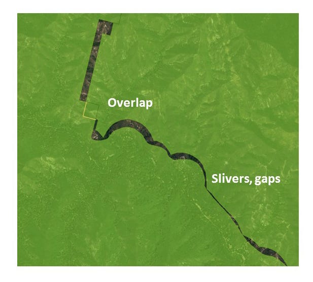
- PAD-US has made great progress with version 2.0 in reducing incidental overlaps and slivers among Federal agencies and future editions should continue this trend. Agencies are being encouraged and supported by PAD-US to sort out their ownership overlaps and provide clean source data into PAD-US.
- PAD-US also has a number of feature classes that intentionally overlay one another — for example, some easements overlay fee lands or other easements; many designation or proclamation boundaries overlay fee and/or easement lands, as well as other designations/proclamations. These are not errors — they’re an accurate reflection of the world of protected areas data. But they can create challenges to GIS users. In PAD-US version 2.0, designations and proclamation boundaries are in separate feature classes which has helped address this issue, but the fact remains that overlapping boundaries are a key part of this dataset.
Attributes/Data Dictionary
- There are approximately 30 core fields in each PAD-US data layer, divided between fields that come from source agencies (‘Local_Owner’, ‘Local_Name’, etc.) and those created by the PAD-US team from domain values (e.g., ‘Designation’ Type) or from defined calculations (e.g., GAP Status Code):
- USGS adds value to agency provided source data by managing several additional attributes. The following attributes are assigned categorically by Designation Type or transferred between PAD-US updates when more information is available:
- GAP Status Code — A nationally relevant measure of management intent for the long-term conservation of biodiversity. Areas managed for multiple uses (including extraction) area also classified.
- International Union for the Conservation of Nature (IUCN) Category — A conservation measure used to track global progress toward Convention for Biological Diversity protection targets through the World Database on Protected Areas (WDPA).
- World Database on Protected Areas (WDPA) ID — A persistent identifier assigned by the UNEP — World Conservation Monitoring Center and managed by USGS between PAD-US updates to identify each protected area by name and designation type.
- Public Access — The general level of public access permitted in the area (i.e. Open, Closed, Restricted, Unknown).
- Date of Establishment (DOE) — The year the protected area was designated, decreed, or otherwise established. DOE is assigned by name and designation type regardless of overlaps with other areas or event status.
- Many of these fields use domain values (standards for populating these fields) established by USGS. You can download a blank schema or spreadsheet containing all domain descriptions from the PAD-US Data Manual. Users are encouraged to explore this PAD-US Data Manual to learn more about these fields and domain values.
Common Attribute Questions
Designation Type Questions:
What is the difference between Local Park and Local Recreation Area?
- Generally, Local Parks are parks by name. There is a bit of a gray area with Local Parks and Local Recreation Areas. The general rule is a Local Recreation Area should be a more developed site, specifically for human oriented intensive recreation activities. In that sense, anything “Playground / Tot Lot / Skate Park / Court / Field / Swim Center / etc”, would be a Local Recreation Area because it is a stand-alone area dominated by an intensive recreation activity. Most of these examples would normally not be followed by “Park” in the name, except in some cases (like Skate Park, which is properly assigned to Local Recreation Area). However, areas like Community Parks, City Parks, County Parks, Dog Parks, Marina Parks, etc, should be designated as Local Park because they are not necessarily places that are developed specifically for or dominated by intensive recreation activities.
Why are proposed Wilderness Areas included in the standardized Wilderness Study Area designation type?
- While proposed or recommended Wilderness is not legally the same thing as a congressionally designated Wilderness Area, they are managed similarly and are grouped together for PAD-US purposes. See ‘Local Designation Type’ for the official designation type provided by managing agencies.
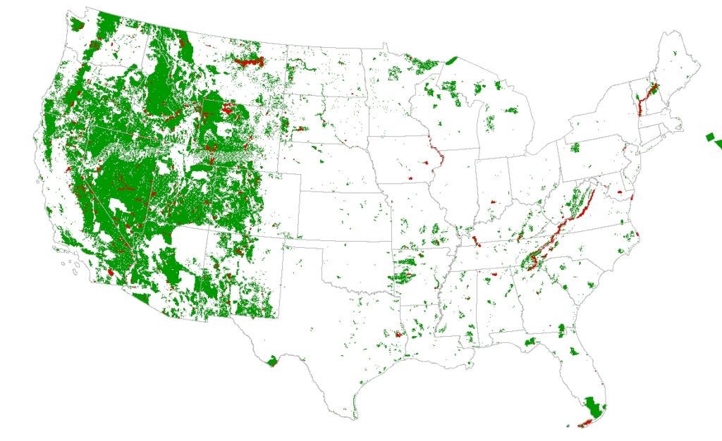
Some western states appear to have more federally owned land than expected. Why is this?
- Although many western states have high percentages of federally owned land, it may appear to be even higher when viewing the ‘Combined’ feature class layers. This is primarily because grazing allotments and herd management areas were included from Bureau of Land Management (BLM) data (Note: PAD-US does not currently include grazing allotment and herd management area data for the Forest Service). These areas do not represent ownership boundaries, but rather general management boundaries. Grazing allotments for example, while administered by BLM for livestock grazing, often include a mix of federal, state, and/or private land with more detailed allotment management plans. For this reason, grazing allotments and herd management areas are also in the ‘Designation’ rather than the “Fee” Feature Class. Other federal Designations (such as National Monuments) may also include non-federal lands.